The Western Ghats: India's Cool Hill Country
Reference library · 1022 words

The Western Ghats are not, strictly speaking, mountains. They are the eroded escarpment of the Deccan plateau, a wall running roughly 1,600 kilometres down the western side of peninsular India from near the Tapti river in Gujarat to the southern tip at Kanyakumari. Geologically they are far older than the Himalaya, and their ecological importance is out of proportion to their modest heights: UNESCO inscribed a serial property of thirty-nine sites across four states in 2012, and the range is recognised as one of the world's biodiversity hotspots, with very high rates of species found nowhere else, particularly among amphibians and freshwater fish.
The escarpment also makes the weather. When the southwest monsoon arrives from the Arabian Sea in June, the wall forces the moist air upward, and it dumps its water on the western slopes. Places such as Agumbe in Karnataka and Amboli in Maharashtra receive extraordinary annual rainfall, while the plateau immediately east lies in the rain shadow and can be semi-arid. There is one significant break in the wall, the Palakkad Gap, a corridor roughly thirty kilometres wide that separates the Nilgiri massif from the Anamalai hills to its south. That gap channels wind and monsoon inland, has carried the main road and rail routes between Tamil Nadu and Kerala for centuries, and acts as a biological divide, with several species on either side of it that do not cross.
Why the hill stations exist
Almost every well-known hill station in the Ghats was founded by the British administration for the same reason: heat. Company officials and their families sought elevated sites where temperatures were tolerable and where sanatoria could be established for troops. Ootacamund, now Udhagamandalam and universally Ooty, was developed in the Nilgiris from the 1820s after the Coimbatore collector John Sullivan built a house there, and became the summer capital of the Madras Presidency. Mahabaleshwar served the same function for Bombay, with Panchgani nearby developing around schools. Matheran, closer to Bombay still, was laid out on a ridge and remains, unusually, closed to motor vehicles: visitors arrive on foot, on horseback, or by the narrow gauge railway from Neral funded by the industrialist Adamji Peerbhoy in the early twentieth century.
Kodaikanal has a different lineage. It was established in the 1840s by American missionaries working in the plains of Madurai, and grew around a school and a lake. Munnar, in Kerala's Kannan Devan hills, was not a resort at all but a plantation headquarters, and its landscape of clipped tea bushes stretching over rounded hills is entirely manufactured.
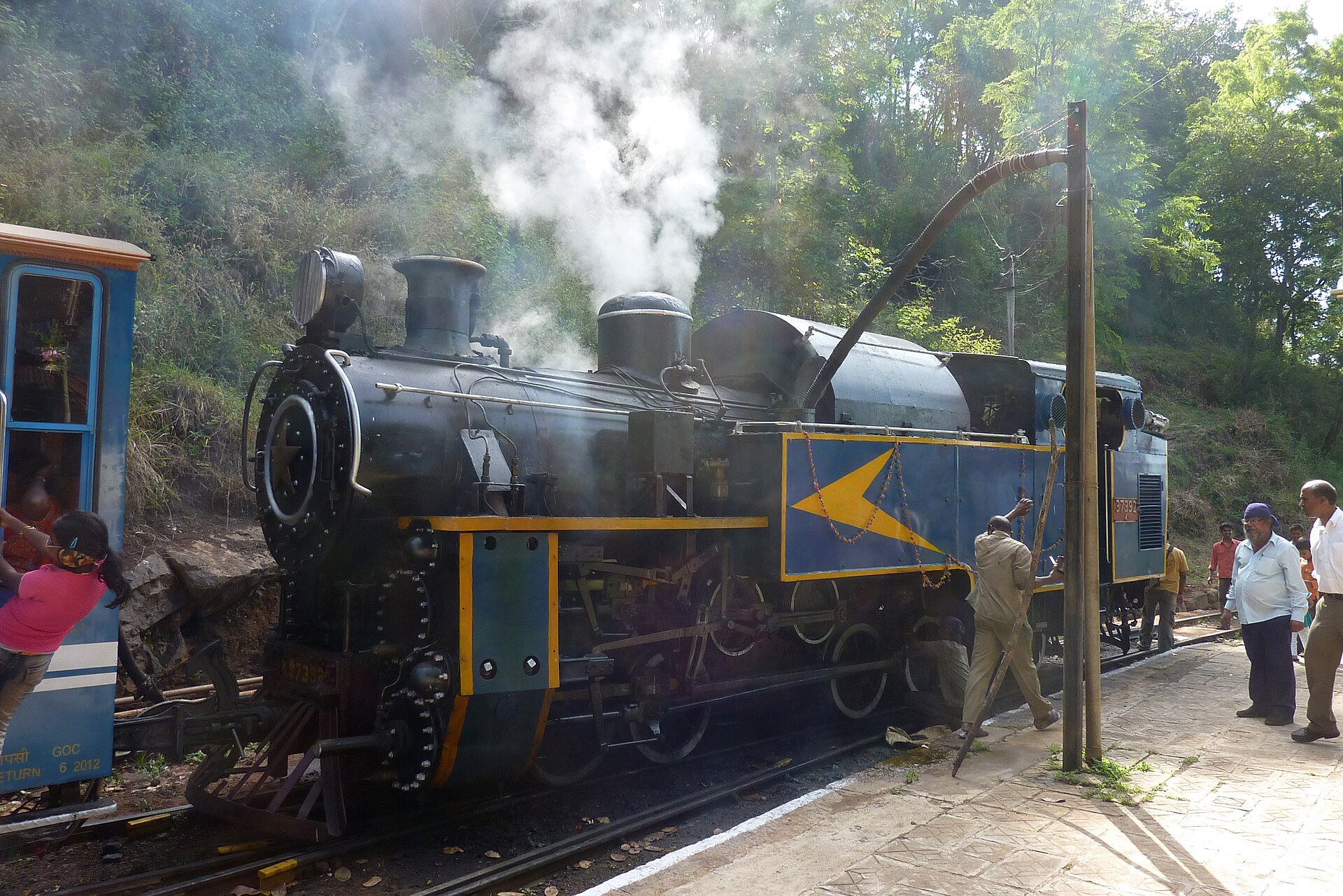
The Nilgiri Mountain Railway, which climbs from Mettupalayam through Coonoor towards Ooty, is the most striking survival of the era. On its steepest section it uses an Abt rack system, a toothed rail engaged by pinions under the locomotive, and it is one of the very few railways in the world still working steam on rack sections. UNESCO added it in 2005 to the Mountain Railways of India inscription that already covered the Darjeeling Himalayan Railway.
Tea, coffee and spice
The plantation economy that reshaped these hills began with coffee. The traditional account credits a Sufi pilgrim remembered as Baba Budan with carrying seven coffee beans out of Yemen and planting them in the Chandragiri hills near Chikmagalur in Karnataka, which now bear his name. The story is old and cherished, but it is legend rather than documented history. What is documented is that by the nineteenth century European planters had established large coffee estates in Kodagu (Coorg), Chikmagalur and Wayanad, and that India remains a substantial producer of both arabica and robusta, most of it grown under shade trees, which is one reason Indian coffee estates retain more bird life than open plantations elsewhere.
Tea followed on the higher, wetter slopes of the Nilgiris and the Kannan Devan hills, and required labour on a scale the hills could not supply. Workers were recruited in large numbers from the plains of Tamil Nadu and beyond, and their descendants form settled plantation communities whose wages, housing and land rights remain live political issues in both Tamil Nadu and Kerala. Cardamom, pepper and, around Thekkady, the spice trade that first drew foreign ships to this coast, occupy the middle elevations.
What survives, and what nearly did not
The wild Ghats are best seen in the protected areas rather than the towns. Eravikulam National Park above Munnar holds Anamudi, at roughly 2,695 metres the highest peak in India south of the Himalaya, and the largest population of the Nilgiri tahr, a stocky wild goat found only in these hills. The shola-grassland mosaic of the high Nilgiris and Anamalais, in which stunted evergreen forest survives in sheltered folds surrounded by open grass, is a distinctive and much reduced habitat. Every twelve years or so the shrub Strobilanthes kunthiana, the neelakurinji, flowers in mass across these slopes and turns them blue, an event that draws enormous crowds and considerable exaggeration about its precise timing.
Silent Valley in Kerala is the range's most consequential conservation story. A proposal to dam the Kunthipuzha river for hydroelectricity in the 1970s met sustained opposition from scientists, poets and local activists concerned about one of the last substantial tracts of undisturbed tropical evergreen forest in the country and its lion-tailed macaques. The project was abandoned and the area declared a national park in 1984, an outcome widely treated as the beginning of modern environmental campaigning in India.
The indigenous communities of these hills predate every plantation and hill station. The Toda of the Nilgiri plateau, buffalo pastoralists whose barrel-vaulted thatched temples and embroidered shawls are distinctive, are the best known, but the range is home to many groups, and land alienation to estates and reserves has affected most of them.
For visitors, timing is the main decision. The hill stations are busiest from April to June, when the plains are unbearable. The monsoon between June and September brings landslides, leeches and closed roads, but also the waterfalls the range is known for, including Jog Falls on the Sharavathi in Karnataka, whose flow now depends on dam releases. The clearest travelling weather is generally from October to March.
References
- UNESCO World Heritage CentreWestern Ghats
- UNESCO World Heritage CentreMountain Railways of India
- Encyclopaedia BritannicaWestern Ghats
- Encyclopaedia BritannicaNilgiri Hills
This is a reference article, written from the sources above. It is background, not news reporting.