Tracing the Char Dham Pilgrimage Through the Himalayas
Reference library · 1008 words

Ask for the Char Dham and you may be given either of two answers, and the confusion is worth clearing before anything else. The older Char Dham is a national circuit of four shrines at the compass points of the subcontinent: Badrinath in the Himalaya, Dwarka in Gujarat, Puri in Odisha and Rameswaram in Tamil Nadu. Tradition attributes the grouping to Adi Shankara. The circuit most Indians now mean when they say Char Dham is the Garhwal one, sometimes distinguished as the Chota Char Dham: Yamunotri, Gangotri, Kedarnath and Badrinath, all in Uttarakhand, all above 3,000 metres. Only Badrinath belongs to both. The Garhwal grouping is comparatively modern as a named set, consolidated in the twentieth century as motor roads reached the valleys and pilgrimage that once took months became a matter of days.
The order is conventionally west to east, following the natural progression of the valleys: Yamunotri, then Gangotri, then Kedarnath, then Badrinath. Devout travellers finish at Badrinath deliberately, and many add a fifth stop at Hemkund Sahib, the high Sikh shrine above the Valley of Flowers, which shares the same season.
Four Shrines and Their Rivers
Yamunotri, in the Uttarkashi district, honours the Yamuna. The actual glacial source at Champasar lies higher and is not the site of worship; the temple sits below it, reached by a walk of several kilometres from Janki Chatti. Its distinguishing feature is the Surya Kund, a hot spring beside the shrine so hot that pilgrims lower rice and potatoes tied in muslin into it and carry the cooked food away as prasad. The temple has been rebuilt more than once after avalanche and flood damage.
Gangotri stands on the Bhagirathi, the headstream that Indian tradition treats as the Ganga proper. The temple, of white granite, was built in the early eighteenth century, associated with the Gorkha commander Amar Singh Thapa, and later restored. The glacier snout at Gaumukh, from which the Bhagirathi emerges, lies roughly eighteen kilometres upstream on foot through the Gangotri National Park, and the shrine marks the accessible substitute for a source that keeps retreating. The stone slab where Bhagiratha is said to have performed austerities to bring the river down stands beside the temple.
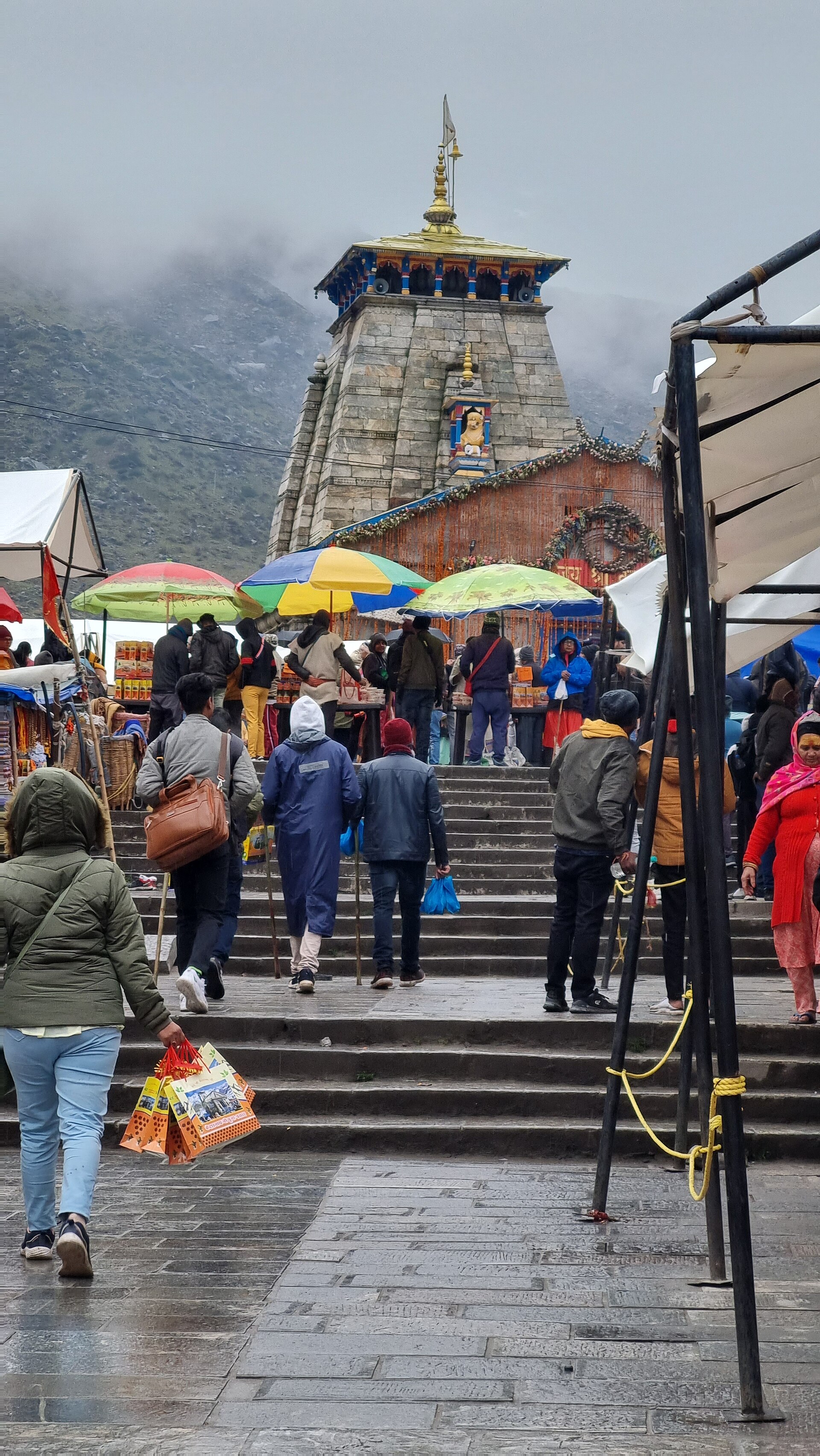
Kedarnath, in the Mandakini valley, is the most physically demanding and the most striking. The grey stone temple, of uncertain date and long associated in tradition with the Pandavas and with Adi Shankara, stands at about 3,580 metres on an open shelf with the Kedarnath and Kharchakund peaks behind it. It is one of the twelve Jyotirlingas and the principal shrine of the Panch Kedar group. The approach is a climb of roughly sixteen kilometres from Gaurikund, made on foot, by pony, by palanquin or, increasingly, by helicopter.
Badrinath sits on the Alaknanda beneath Nilkanth peak, its brightly painted gateway incongruous against the rock. It is a Vaishnava shrine, one of the 108 Divya Desams celebrated by the Tamil Alvar poets, and the hot springs of Tapt Kund below the temple are used for bathing before entry. Its most distinctive institution is the priesthood: the head priest, the Rawal, is by long tradition a Nambudiri Brahmin from Kerala, a southern lineage maintained at the northern edge of the Himalaya, which is generally explained as a legacy of the Shankara tradition.
A Season, Not a Year
All four shrines close for winter. The doors open around Akshaya Tritiya in late April or early May and close around Bhai Dooj, shortly after Diwali, in late October or November. The deities do not simply wait. Each has a winter seat to which the processional image is carried in formal procession: Badrinath's to the Narsingh temple at Joshimath, Kedarnath's to Omkareshwar at Ukhimath, Gangotri's to Mukhba and Yamunotri's to Kharsali. Worship continues uninterrupted at the lower village, which is why the circuit is better understood as a seasonal migration than as a closure.
The road itself is part of the pilgrimage. Travelling up from Rishikesh, the route passes the Panch Prayag, the five confluences of the Alaknanda system: Devprayag, where the Bhagirathi and the Alaknanda meet and the river is first called the Ganga, then Rudraprayag, Karnaprayag, Nandaprayag and Vishnuprayag. Each has a temple and a stone platform above the water, and together they give the drive a structure that a map alone does not convey.
Floods, Roads and the Question of Scale
In June 2013 an exceptional rainfall event combined with the breach of a moraine dammed lake above Kedarnath sent debris flows through the settlement. Thousands died across Uttarakhand, much of Kedarnath town was destroyed, and the temple survived largely because a large boulder lodged behind it and split the flow. The reconstruction that followed rebuilt the approach and the town on a different plan, but the underlying lesson was about siting: guesthouses, shops and parking had been built into an active floodplain across decades of unregulated growth.
The response has been contested ever since. The Char Dham Pariyojana, a programme to widen the approach roads into an all weather highway network, has been litigated repeatedly, with scientists and petitioners arguing that hillside cutting on this scale destabilises slopes in a young and seismically active range, and the state arguing for access and strategic need. Land subsidence at Joshimath, the winter seat of Badrinath, brought the argument into a town rather than a courtroom. Meanwhile helicopter shuttles, online registration systems and daily caps attempt to manage numbers that now run to millions in a season.
Practical advice follows from the geography rather than from any guidebook. The window is late April to June and mid September to early November; July and August bring the monsoon and with it landslides that routinely close the roads. Altitudes above 3,000 metres warrant a slow ascent and a rest day, and cardiac emergencies among older pilgrims are a recurring cause of deaths on the route. Nanda Devi and the Valley of Flowers, inscribed as World Heritage, lie within the same watershed, a reminder that the corridor is a protected ecological zone as much as a religious one.
References
- Shri Badarinath Shri Kedarnath Temple CommitteeOfficial temple committee site
- Uttarakhand Tourism Development BoardUttarakhand Tourism
- UNESCO World Heritage CentreNanda Devi and Valley of Flowers National Parks
- Incredible India, Ministry of TourismUttarakhand
This is a reference article, written from the sources above. It is background, not news reporting.