The Long, Green Drive Along Coastal Karnataka
Reference library · 1094 words

Karnataka's coast runs about three hundred and twenty kilometres, from the Kali river at Karwar in the north to the Netravati at Mangaluru in the south, and it is one of the most compressed landscapes in India. The Western Ghats escarpment rises within twenty or thirty kilometres of the sea for most of that length, so rivers are short and steep, estuaries are wide, and the coastal plain is a green strip of paddy, coconut and areca squeezed between rock and water. National Highway 66, still called NH 17 by older drivers, threads the whole of it, and the Konkan Railway runs roughly parallel a little inland. Three districts share the coast: Uttara Kannada in the north, then Udupi, then Dakshina Kannada.
The Road and the Ghats Behind It
The northern stretch is the wildest. Karwar sits at the mouth of the Kali, with the naval base at Kadamba nearby and the beach at Devbagh across the estuary. South of it, Gokarna is two towns in one: an old pilgrimage settlement built around the Mahabaleshwar temple, and a string of headland separated beaches, Kudle, Om, Half Moon and Paradise, reached by cliff paths or by boat. The temple houses the Atmalinga of the local legend, in which Ravana is tricked into setting down a linga he was forbidden to place on the ground, and the story explains the shrine's name and its standing among Shaivas. Visitors should understand that Gokarna is a functioning temple town with dress and behaviour expectations that do not evaporate on the beach.
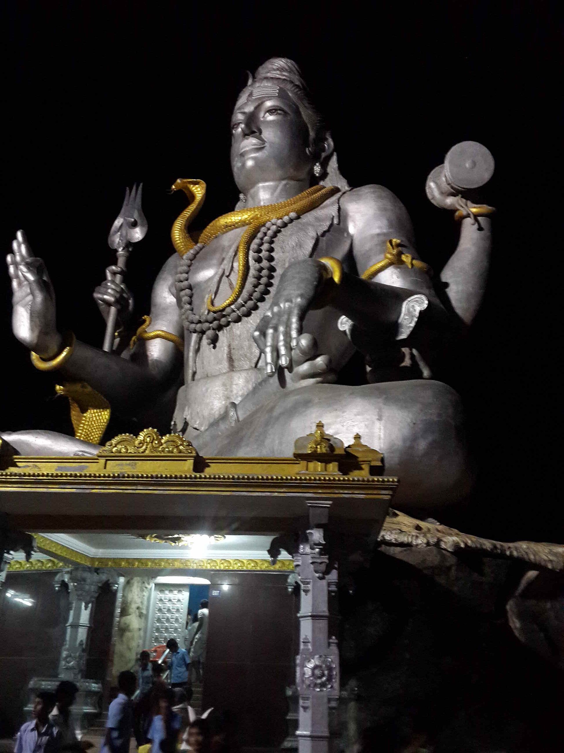
Murudeshwar, further south, is unmissable in the literal sense: a colossal seated Shiva and a twenty storey gopura rise on a headland, both built in recent decades with the patronage of a local industrialist, and both illustrate that coastal Karnataka's temple building did not stop in the medieval period. Inland from Honnavar, the Sharavathi river drops in four separate falls at Jog, named Raja, Rani, Rocket and Roarer; the volume depends entirely on releases from the Linganamakki dam upstream, so the spectacular version is a monsoon and immediate post monsoon phenomenon. Bhatkal, back on the coast, is a distinctive place: a town with Jain basadis in the local sloping roofed idiom and a long established Nawayath Muslim community whose mosques, trade links across the Arabian Sea and Konkani inflected speech mark it out from its neighbours.
Between Kundapura and Udupi comes the stretch drivers remember: at Maravanthe the road runs on a narrow bar with the Souparnika river on one side and the Arabian Sea on the other, water visible from both windows. Kollur, inland, holds the Mookambika temple, a major Shakta shrine drawing large numbers of pilgrims from Kerala.
Temples, Basadis and Rock
Udupi is the pivot of the coast. The Krishna Matha was founded by Madhvacharya in the thirteenth century, and worship there follows an unusual arrangement: eight monasteries, the Ashta Mathas, take turns administering the temple in a rotation called the Paryaya, with the handover held every two years in a large public ceremony. The image is viewed through the Kanakana Kindi, a small carved window, the tradition being that the deity turned to face a devotee refused entry. Nearby, Malpe is the working fishing harbour and the departure point for St Mary's Islands, where columnar basalt rises out of the sea in hexagonal pillars. These are recognised as a national geological monument, and the rock is significant beyond its appearance: the columns are evidence used in reconstructing the rifting that separated Madagascar from the Indian plate. Kaup's black lighthouse on its rock and the Barkur temples fill the gaps.
Mangaluru at the southern end is a port city with an unusually layered religious geography: the Mangaladevi temple that gives the city its name, Kadri Manjunath with its early bronze images, the Jain bastis of Moodabidri and the thousand pillar temple a short drive inland, and St Aloysius Chapel, whose interior was painted end to end by the Italian Jesuit artist Antonio Moscheni in the 1890s. Sultan Battery, a small watchtower built by Tipu Sultan on the Gurupura backwaters, marks the older military frontier.
Behind all of it, the Western Ghats section inscribed as World Heritage runs the length of the drive. Detours inland reach Agumbe, with its rainforest research station and reputation for extreme rainfall, and the Sharavathi and Aghanashini valleys, where estuarine bivalve gathering and mangrove systems support a village economy that rarely appears in tourism material.
What the Coast Eats, and What It Argues About
Two distinct food cultures share this shoreline. The vegetarian tradition of the Shivalli Brahmin community of Udupi produced the temple kitchen style that later travelled across India as the Udupi hotel: rice, sambar, rasam, palya, and a repertoire of tiffin dishes served fast and cheaply. That diaspora of cooks and restaurateurs, moving to Mumbai, Chennai and beyond through the twentieth century, is one of the most consequential food migrations in modern India. It has also produced origin claims that should be handled carefully. Udupi is often credited with inventing the masala dosa, and idli is sometimes given a precise Udupi birthplace; neither claim is documented, and the food historian K T Achaya's suggestion that idli's fermented and steamed technique may have arrived from the Indonesian archipelago remains a hypothesis rather than an established finding. Karnataka and Tamil Nadu both make claims on these dishes. The honest position is that they developed across the southern peninsula and that no region can show a founding document.
The other tradition is emphatically not vegetarian. Coastal Karnataka's fish cookery uses coconut, roasted red chilli, tamarind and the sour kokum and bimbli fruits: Mangalorean fish curry, anjal and bangude fried in a rava crust, neer dosa's thin rice crepes, and kori rotti, chicken curry poured over brittle sheets of dried rice bread until they soften. Ghee roast, now on menus nationwide, is associated with Kundapura. The Byari Muslim community and the Gowd Saraswat Brahmins each add their own repertoire, the latter's pathrode of colocasia leaves rolled with spiced rice batter being a genuine coastal signature.
Timing matters more here than on most Indian routes. The monsoon between June and September is heavy and the sea unswimmable, but the Ghats are at their most dramatic and Jog Falls at full flow. October to February is the comfortable driving season. Highway widening has been under way for years in sections, and the older single carriageway with its causeways and ferries has largely gone, which has made the drive faster and, in the view of many who knew it before, considerably less interesting.
References
- Karnataka TourismKarnataka Tourism
- UNESCO World Heritage CentreWestern Ghats
- Incredible India, Ministry of TourismKarnataka
- Incredible India, Ministry of TourismMangalore
This is a reference article, written from the sources above. It is background, not news reporting.