Drifting Kerala's Backwaters: A Slow Water Journey
Reference library · 1033 words
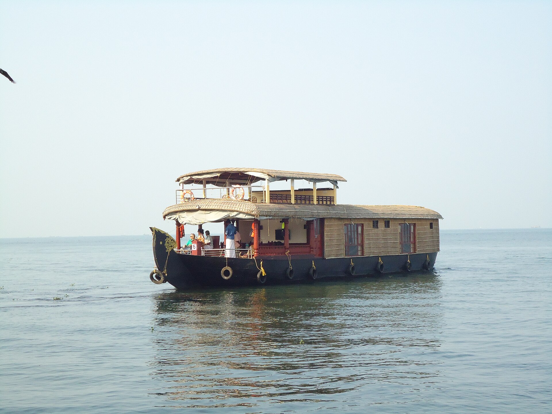

The backwaters of Kerala are not a lake, a river or a lagoon, but a linked system of all three. Along roughly the southern half of the state's coast, a chain of brackish lagoons and lakes sits behind a long sand barrier, fed by rivers running down from the Western Ghats and connected to the Arabian Sea through a small number of tidal mouths. Vembanad, the largest of these lakes and the longest in India, stretches from Alappuzha district north towards Kochi. Ashtamudi, further south near Kollam, is a branching palm-shaped lake whose eight arms give it its name. Canals, some natural and some cut for the coir and rice trade, join the lakes into a navigable network that once carried most of the region's freight.
Travelling this network slowly is the point. Roads in coastal Kerala are congested and the distances look short on a map, but the water route reorganises the geography: villages face the canal rather than the road, shops open onto jetties, school children commute by ferry, and the traveller passes through daily life at walking pace. The classic long journey is the State Water Transport Department ferry between Kollam and Alappuzha, which takes most of a day and threads the full length of the southern backwaters for the price of a bus ticket. It is slower and far cheaper than the tourist cruises, and it stops where people actually live.
How the houseboat was invented twice
The vessel most associated with the backwaters, the kettuvallam, began as cargo. The name means, roughly, a boat that is tied: the hull planks, traditionally of anjili (wild jackfruit) wood, were stitched together with coir rope and sealed with resins and fish oil rather than fastened with iron nails, a technique that produced a flexible hull well suited to shallow, shifting channels. These barges carried rice from the Kuttanad paddy lands, coir from Alappuzha and spices bound for the ports. Road and rail freight made them redundant during the twentieth century, and from the 1990s owners began converting the surviving hulls, and then building new ones, as floating guesthouses with thatched roofs of woven palm.
The result is genuinely comfortable and genuinely popular, which has created its own difficulties. The houseboat fleet on Vembanad has grown to a scale that regulators and ecologists have repeatedly warned about, with concerns centring on sewage discharge, engine oil and the sheer congestion of the main channels near Alappuzha. Travellers who want quieter water increasingly start further out, from Kumarakom on the eastern shore, from Kollam and Munroe Island in the south, or from the smaller canals around Kottayam, where a paddled country canoe reaches places no houseboat can enter.
A landscape that farms below the sea
Behind the lakes lies Kuttanad, one of the very few places on earth where rice is grown below sea level. Fields called padasekharams sit inside earthen bunds, several feet lower than the water outside them, and are drained by pumps before sowing. The system was extended through the nineteenth and twentieth centuries by reclaiming lake bed, and it depends entirely on keeping salt water out during the dry months. That is the job of the Thanneermukkom barrier, a regulator built across Vembanad Lake in the second half of the twentieth century to block the tidal push of saline water upstream. It protected the rice, but it also cut the lake's natural flushing cycle, and it is widely blamed for the weed growth, reduced fish diversity and stagnation in the upper lake. The trade-off between farming and estuarine health is still argued over locally, and no consensus has emerged. The Food and Agriculture Organization of the United Nations has recognised the Kuttanad below-sea-level farming system as an agricultural heritage system of global importance, which is a recognition of ingenuity rather than a verdict on the ecology.
Vembanad is also a wetland of international importance under the Ramsar Convention, and the Kumarakom Bird Sanctuary on its shore is the most convenient place to see why: egrets, herons, darters and, in the northern winter, migratory ducks and waders. Ashtamudi, the southern lake, supports a short-neck clam fishery that has drawn international attention as an unusually well managed small-scale fishery.
Boats, races and what to eat
The backwaters' most spectacular day is a race. The chundan vallam, or snake boat, is a war canoe form perhaps a hundred feet long, low at the centre and rearing to a tall carved prow at the stern, crewed by more than a hundred rowers who paddle to sung vanchipattu rhythm. The best known race, the Nehru Trophy, is held on Punnamada Lake at Alappuzha and takes its name from Jawaharlal Nehru, who watched a race there in the early 1950s. Other village races run through the Onam season, roughly August and September, and are older and less commercial affairs tied to particular temples and villages.
Food along the water is distinct even by Kerala standards. Karimeen pollichathu, pearl spot fish rubbed with chilli and shallot masala, wrapped in a banana leaf and pan-roasted so the leaf chars, is the dish visitors are most often served on a houseboat. Duck curry with coconut, kappa (tapioca) with fish, prawns from the paddy-field aquaculture cycle, and Syrian Christian dishes such as meen vevichathu soured with kudampuli (Malabar tamarind) all belong to this stretch of coast. Toddy shops, or kallu shappu, sell fermented palm sap alongside deliberately fierce food; they are ordinary local establishments rather than attractions, and the better ones are found by asking.
Alappuzha is often called the Venice of the East, a label commonly attributed to Lord Curzon, though the attribution is repeated more confidently than the evidence supports. The comparison is in any case misleading. Alappuzha was built as a working port town in the eighteenth century under the Travancore minister remembered as Raja Kesavadas, with canals cut to move coir and pepper to a pier, and its charm is industrial rather than aristocratic. The best months to travel are roughly November to February, when the humidity eases; the southwest monsoon from June brings the water high, the fields green and the crowds away, which some travellers prefer and others find impossible.
References
- Kerala Tourism (Government of Kerala)Backwaters of Kerala
- Food and Agriculture Organization of the United NationsGlobally Important Agricultural Heritage Systems (GIAHS)
- Ramsar Convention on WetlandsThe Convention on Wetlands
- Encyclopaedia BritannicaKerala
This is a reference article, written from the sources above. It is background, not news reporting.